Yule Calder Loop, England, UK and Ireland - Trail Running Directory - Wild Things

Last Updated: 31st Jul 2024

Intermediate

Save Trail Save

I've done it Done

Yule Calder Loop

Submitted by Katie Smith

Last Updated: 31st Jul 2024

Intermediate

Save Trail Save

I've done it Done

Open

Grunt Factor: 16 ?

Gnarl Factor: 28 ?

12.9km

335m

335m


Become a VIP to see driving directions, distance and time.

Trail Map

This Topo layer only covers NSW/ACT.
Switch to another map layer when viewing outside this area.

Type of Run

Front country - easily accessible

Loop

Undulating, small hills only

Riverside

Open farmlands

Open tussock/grasslands

Open ridges/tops

Run Makeup

15%
60%
25%

Sealed Road

Farm Road / 4WD Track

Untracked / Route only

Average Uphill Gradient: +5.20%

Average Downhill Gradient: -5.20%

Garmin Course

VIP Feature: Send this route to your Garmin account so you can follow the course on your Garmin device.

Send to Garmin

Learn about sending to Garmin.

Trailhead

Become a VIP Member to see the trailhead information.

Estimated Times to Run

2:30

Slow

1:50

Moderate

1:20

Fast

We are eager to expand our Trail Running Directory in the UK and Ireland. Submit a trail and earn a free month of VIP.

Submit a new trail now

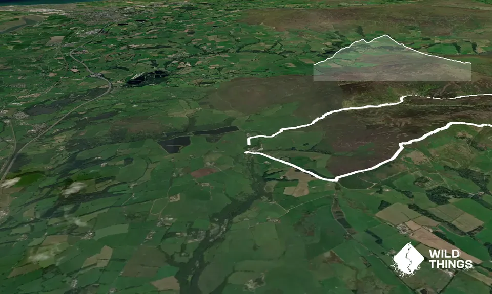
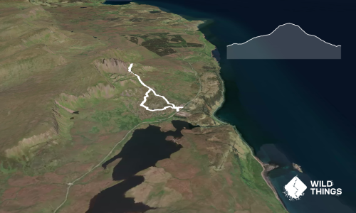
This is a great mixed loop with some off-track following your nose along a stream to connect track ends.

Start at the Oakenclough crossroads and head up the hill on the road. At the end of the plantation on your left head through a forestry gate and follow the track alongside the fence/wall gradually climbing up to Stang Yule.

At the first junction keep left, and again at the next two. The track will turn and start to head north. It then drops down to cross the Calder stream.

At this point the off-track section starts - follow the stream downstream, picking up rough sheep tracks and crossing wherever you need to. This is slow going with scrub and some boggy patches, but very pretty.

Eventually, you will come across a little bothy and barn, and the start of a 4WD track. Follow this out until it meets the road, turn left and head back along to the Oakenclough crossroad start point.

If you know of any public toilets near the trail start or on the route, please login and then let us know so we can update this section.

Unknown

No

Moderate.

Very patchy.

Long-sleeved thermal top, Seam-sealed waterproof jacket, Whistle, First aid kit, Extra food for emergencies, Cellphone, Map

Do you have a suggestion on where to go afterwards for the best coffee / cake / breakfast / brunch / beer?

You and Yule Calder Loop

As a VIP member you can record private notes for this trail, see all of your times and more.

Become a Member

Already have an account? Login now

Trail Reviews

Be the first to submit a review for Yule Calder Loop!

Login to submit a review

Trail Running Community

Find people who are interested in or have completed this trail run.

You must register or login to view this feature.

Register Now

Overlapping Trails

These overlap with this trail to some degree. You may wish to combine them but please note that to qualify for FKTs on these runs you should record a separate activity for each.

Stang Yule

Stang Yule

Length: 13.7km

Level: Beginner - Intermediate

Other trails nearby
Ben Lomond- Ptarmigan Ridge Loop

Ben Lomond- Ptarmigan Ridge Loop

Length: 12.5km

Level: Intermediate

The Horns of Alligin

The Horns of Alligin

Length: 11.1km

Level: Intermediate

The Old Man of Storr

The Old Man of Storr

Length: 5.2km

Level: Beginner - Intermediate

Scafell Pike Out and back

Scafell Pike Out and back

Length: 10.8km

Level: Intermediate

Find more trails and peaks nearby

Wild Things
Wild Things
Explore more

Plan smarter, stay motivated, track your progress, and unlock the full Wild Things experience — while saving along the way.